Search
-
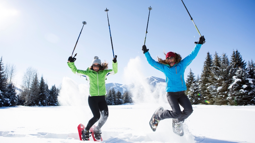
The Unmatched Health Benefits of Snowshoeing
Snowshoeing is an excellent winter workout that can help burn calories, strengthen muscles and boost cardiovascular health. Explore the top 8 snowshoeing spots and experience this ultimate workout adventure! Significant Health Benefits: Exceptional cardiovascular workout – burn up to 1,000 calories per hour! Low-impact muscle building Endurance building Balance strengthening and agility Improves your sense of well-being by connecting to nature Prepping for Your Adventure There are some crucial details to think about when it comes to snowshoeing, especially if you are a beginner. Make sure to pick the right kind of footwear to go on top of your snowshoes; a pair of comfortable waterproof boots are a great choice and remember to wear lots of layers. Several local places rent snowshoes if you aren’t sure about spending money on a pair. Check out Bobos Ski and Board Patio or our local REI Co-Op. Check out REI’s Beginner’s Guide to Snowshoeing for reference. 8 Cool Snowshoeing Spots 1. Galena Creek Park Close to Reno, this beautiful, low-altitude park offers several trails. You’ll find various creeks and streams under cover of pristine ponderosa pines. From beginner to advanced, the differing trail systems provide a challenge for everyone! Head west on State Route 431 (Mt. Rose Highway) for about seven miles until you see the park sign on the right side of the highway. 2. Tahoe Meadows – Chickadee Ridge This local favorite not only gives fantastic views of Lake Tahoe but the best part? – friendly little chickadees will eat seeds right out of your hand! Be sure to pack plenty of sunflower birdseed, as that seems to be their favorite. From the trailhead parking lot, head southeast into the open meadow. Then follow the ridgeline to your right (southwest). Continue southwest up toward the top of the ridgeline to the west, and you’ll get to Chickadee Ridge in just under two miles. 3. Spooner Lake Trail The easy 2.5-mile loop around Spooner Lake is excellent for all skill levels. This alpine lake is surrounded by aspen trees which house varied bird species, so bring your binoculars! Dogs are allowed on a leash, and all-day parking is $10. 4. Kirkwood Ski Resort You’ll need a trail pass, but this South Lake Tahoe resort has various routes from beginner to advanced, with roughly 50 miles of terrain. Nighttime snowshoe treks during the full moon are also available throughout the winter. Kirkwood is located on Highway 88, close to Carson Pass. 5. Camp Richardson Heading north, you can find this well-established and favorite local snowshoeing spot. If you’re up for an adventure, you can trek up to Fallen Leaf Lake. It’s located off Highway 89 and near Fallen Leaf Road. 6. Dry Pond Loop This moderate, 6.5-mile loop near Washoe Valley has impressive views of Carson Valley, Washoe Lake, and the Mt. Rose Wilderness. If you like the sound of rushing water, most of the trail meanders along White’s Creek. This area is dog-friendly and kid-friendly, which makes it a family favorite. 7. Royal Gorge Soda Springs is home to this resort, which is well known for its cross-country skiing trails. Enjoy extensive trails leading deep into the trees with spectacular views. Find Royal Gorge from the Soda Springs exit on West Interstate 80. 8. Ash Canyon Creek Tucked away in the Carson Valley, these trails are filled with mountain bikes in the spring and provide excellent snowshoeing trails in the winter. Find it from Interstate 580 by taking the Highway 395 Business exit to Winnie Lane.
Read More About The Unmatched Health Benefits of Snowshoeing
-

How to Treat a Sprain or Strain
Injuries happen to everyone. They are caused by participating in sports, recreational activities like hiking, and even by accidentally stepping off a curb wrong. If you experience a sprain or strain, the first few days are often the most painful. Renown Sports Medicine physicians Luis Palacio, MD and Brandon Hockenberry, MD walked us through what to do after an injury. Listen to Your Body See a medical professional right away if: You know or suspect that a bone is broken You are having difficulties putting full weight on a joint of the leg Pain or swelling is severe There is a sign of an infection, such as redness and warmth in the joint The First 24-72 Hours Joint sprains tend to swell more than muscle strains. You can use ice as needed for comfort and to relieve any pain, but do not use ice for more than 15-20 minutes at a time. Ice and NSAIDs (such as ibuprofen) can help prevent excessive swelling and mask the pain, but they do not speed recovery. Some research shows that overuse of ice actually delays recovery. During the first 24-72 hours, your injury will go through an inflammation phase. Inflammation is your body’s natural way to dispose of dead tissue cells, build new healthy structures, and hopefully heal even stronger than before.
-
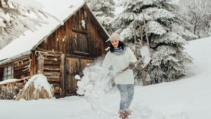
6 Tips for Safe Snow Shoveling
While the appearance of a winter wonderland in your yard can be a welcome one, an accompanying aspect is not: the idea of clearing your driveway and sidewalks. The sometimes-daunting task of snow shoveling is a repetitive activity that can cause muscle strain to the lower back and shoulders. However, by following the tips below, you will spend more time appreciating your winter wonderland -- when your sidewalk and driveway are all clear, that is. But, we all know that injuries happen, and if you do find yourself with back pain that does not resolve in a few days, contact your primary healthcare provider, or visit a Renown Urgent Care. Another way to avoid injury during strenuous activity, or help heal an injury that won't go away, is to work with a physical therapist who can offer at-home exercises to keep your body strong. 6 Tips for Safe Snow Shoveling Following these tips from the American Physical Therapy Association can help you avoid injuries: Lift smaller loads of snow, rather than heavy shovelfuls. Be sure to bend your knees and lift with your legs, rather than your back. Use a shovel with a shaft that lets you keep your back straight while lifting. A short shaft will cause you to bend more to lift the load. Using a shovel that’s too long makes the weight at the end heavier. Step in the direction where you are throwing the snow to prevent the low back from twisting to help prevent “next-day back fatigue.” Avoid excessive twisting because the spine cannot tolerate this motion. Bend your knees and keep your back as straight as possible so that you are lifting with your legs. Take frequent breaks when shoveling. Stand up straight and walk around periodically to extend the lower back. Backward bending exercises while standing will help reverse the excessive forward bending of shoveling. Stand straight and tall, place your hands toward the back of your hips and bend slightly backward for several seconds. When in doubt, ask for help. The Reno community is a generous one and you can typically find snow shovelers for hire on local message boards like Nextdoor and Facebook. Or, if you have a kid in your neighborhood, they might be looking to make some extra money on a snow day.
-

Emergency Hiking Kit Essentials
With the help of Aaron Bertalmio, MD of Renown Urgent Care, we're sharing nine essential must-have items for your hiking emergency kit. 9 Essential Items For Your Hiking Emergency Kit With more than 300 days of sunshine in Reno-Tahoe and plenty of trails to explore, you'll want to keep these essential items in your kit. 1. Water Surprisingly, this no-brainer, however, is often overlooked. Bring enough water to last for the entire adventure. This amount of water can be heavy depending on the distance, altitude or intensity. With this in mind, the next best bet is to filter or purify water from a lake or stream. Here's how: You can do this with iodine or chlorine dioxide tablets, charcoal or an ultraviolet light wand. Tip: Look for water that is moving or rushing over rocks. Having enough water or filtration cannot be underestimated. "If you become injured and need to wait for help, you can only last about three days without water," Dr. Bertalmio says. 2. Food Meals-Ready-to-Eat (MREs) or dehydrated food pouches are essential, ensuring you have plenty to eat if you're outdoors longer than expected. 3. Maps Bring a printed map, compass or GPS. You can't always rely on your smartphone, so this is the perfect backup plan. 4. First-Aid Supplies Your hiking first-aid kit should change based on the type of hiking. As a basic rule, keep the following items in your pack: Fever/pain reliever Sewing kit with safety pins Tweezers Bandages and moleskin Antibiotic ointment Duct or medical tape Whistle 5. Light Source Wear or pack a small headlamp to illuminate the way if you get caught outside after sunset or in a poorly lit area. Headlamps are also great in emergencies because they are hands-free. 6. Emergency Shelter Even if you're only going out for the day, pack a low-weight emergency blanket for the trip. In other words, if the day trip turns into an overnight adventure, the blanket will keep you warm and alive in the event of cold temperatures. 7. Fire Starter Pack small tools in your hiking emergency kit to ensure an easy fire start. Waterproof matches, a knife, a lighter, or a strike fire starter are great options. Tip: Bring a multi-tool, including a knife and scissors that can be used for first-aid. 8. Layers of Clothing Mother Nature likes to change her mind in northern Nevada, and temperatures vary significantly within 24 hours. Therefore, pack a compact, lightweight waterproof and windproof jacket. This will protect you from being uncomfortably chilly and experiencing hypothermia. "Hypothermia is when your body temperature drops to a dangerously low level. You want to avoid this completely by keeping body temperature regulated outdoors and avoiding cold water immersion," says Dr. Bertalmio. 9. Sun Protection Certainly, sun protection should be part of your daily routine and an essential in your hiking emergency kit. You'll want to bring enough sunblock to reapply in direct sunlight and layers to cover exposed skin every two hours. Dr. Bertalmio reminds everyone the sun is intense in northern Nevada. "The higher altitude means an increased risk of sun-induced skin damage," he explains. "Some trails can reach above 10,000 feet, and at that altitude, UV radiation could be 35 to 45 percent more intense than at sea level."
-

8 Local Hiking Trails You Need to Explore
Need fresh hiking trails? These hiking trails offer new views, a different route or the motivation you need to get outside. Of course, whatever you’re looking for this summer, these trails were made for sunshine in Reno-Tahoe. Easy Hiking Trails Oxbow Nature Study Area Nature Trail Location: 3100 Dickerson Road, at the Truckee River. Parking: There is a parking lot onsite. Time Out and Back: 30 minutes Items to Bring: Water, sunscreen and a hat. Although this loop is just under one mile, it’s the perfect escape in the heart of Reno. And this riverside trail is accessible for all skill levels. Bird watcher? Certainly, keep an eye out for black-crowned night herons, red-shouldered hawks, mule deer, beavers and more wildlife in the area. Tahoe-Pyramid Bikeway – Sections 2 to 4 Location: West Reno to Sparks Parking: Woodland Drive, Crissie Caughlin Park, Idlewild Park, 1st Street, Rock Park and Spice Island Drive. Time Out and Back: 2-4 hours (each section, out and back) Items to Bring: Water, sunscreen and a hat. From west Reno to Sparks, this paved portion of the trail stretches more than 8 miles. And it is easy to find as it runs along the Truckee River. As one of the easiest hiking trails in the region, it includes numerous parking access points and you can walk as long or short as you desire. In particular, one great route is from Rock Park on S. Rock Boulevard to Cottonwood Park on Spice Island Drive in Sparks. It’s an easy walk for all hiking levels. Notably many evening hikers explore this area to view the bats living under the McCarran Bridge. Additionally, an array of birds and river views can also be found along this enjoyable path. For maps for sections of this path, visit Tahoe-Pyramid Bikeway’s website. Cave Rock Hiking Trail Location: South Lake Tahoe; turn right on Cave Rock Drive from Highway 50, just prior to the tunnel. Parking: Park on Cave Rock Drive. Time Out and Back: 30 minutes Items to Bring: Water and sunscreen. Not only does this short trail have breathtaking views of Lake Tahoe, but it is also meaningful. Chiefly the rock was created more than three million years ago. Equally important, it is still considered sacred to the Washoe Native Americans. Also, leashed dogs are welcome on the trail. Moderate Hiking Trails Steamboat Ditch Trail Location: To get to the trailhead, take Mayberry Drive in west Reno. Then turn south on Plateau Road and right onto Woodchuck Circle. Parking: There is a dirt area for limited parking. Time Out and Back: 3-5 hours Items to Bring: Water, layers, sunscreen and a hat. Of all the hiking trails listed, this one offers some of the best views of downtown Reno and the surrounding hillsides. Built by Chinese laborers in the late 1870s, the Steamboat Ditch is the longest ditch in the Truckee Meadows region. In fact, the water serves as a vital source for ranchers and farmers south of Reno. First, start behind the Patagonia in northwest Reno at the Tom Cooke Trail or park off of Woodchuck Circle. Next head west to find the “Hole in the Wall.” Surprisingly this is a tunnel engineered through the hill, so the ditch could supply water to the Truckee Meadows. This hike is a little over 8 miles with the halfway point just under 4½ miles. With this in mind, if you’re thinking of hiking with your four-legged friend, remember to bring your leash because rattlesnakes can be spotted. Usually there’s also little shade, so plan accordingly by bringing a hat and dressing in layers. Thomas Creek Trail Location: Head out on Mt. Rose Highway going west to Timberline Road. Then drive 1.3 miles past the end of the pavement, stay on Timberline and you will see the trail head on your left shortly after you cross the bridge. Parking: There is a paved parking area on Timberline Drive. Time Out to Back: 2-6 hours Items to Bring: Water, layers, food and a phone with GPS or map. Definitely put he Thomas Creek Trail on your hiking trails list. Located off of Mt. Rose Highway, it is a very scenic hike winding along Thomas Creek into a Jeffrey pine forest. You may choose to hike to what appears to be the end of the trail (where it meets the road) or continue further up for 1/8 of a mile into the Mt. Rose Wilderness. Hiking up the trail to the creek crossing, and then taking the dirt road back down is a great way to see the entire canyon. While this hiking trail is closer to 5 miles, it can be shortened by turning around at any point. Another option is to look for signs to turn off the Thomas Creek Trail at the junction for Dry Pond Loop. Dry Pond is a 4½-mile, out and back hiking trail from the Timberline parking lot. Ultimately you may see a pond or hilltop meadow, depending on the season and weather. Overall it is possible to go anywhere from 2 to 6 miles (or more), based on what you choose to hike. The gain along the creek is minimal, with an 800-foot gain at the top part of the trail. In particular, watch for mountain bikers, as this is also a very popular biking trail. Hunter Creek Trail Location: Go west on Mayberry Drive to Plateau Road. Then turn left and go up the hill to Woodchuck Drive. Lastly, turn right and follow Woodchuck to the hiking trail head. Parking: Paved parking on Woodchuck Drive with a bathroom and benches. Time Out and Back: 2-5 hours Items to Bring: Water, layers, a snack, sturdy shoes and sunscreen. The Hunter Creek trail is about a 7-mile day hike with a little over 1,000 feet of overall gain leading to a waterfall. Ultimately it’s totally worth the trip! This hiking trail winds up Hunter Canyon through sagebrush, Jeffrey pines and interesting rock formations. The waterfall is a great place to sit on shaded logs and enjoy lunch. This trek is very rocky and narrow at times, so good trail shoes are recommended. Furry friends should also be leashed, as rattlesnakes and wildlife are common along the trail. Difficult Hiking Trails Hidden Valley Loop Location: Hidden Valley Regional Park; drive east on Pembroke Drive and turn left on Parkway Drive. The park is at the end of the road. Parking: Park on the east side of the park, closest to the hills. Time Out and Back: 3-6 hours Items to Bring: Water, sunscreen, shoes with good traction and a lunch or snack. Overall this 6-mile loop has about 1,800 feet of gain and is located east of Hidden Valley. We recommend starting the hike from Hidden Valley Regional Park. First, head southeast on a dirt road and then turn east onto a very steep trail that winds over red dirt for about a half mile. In fact, this is the steepest part and it’s a leg burner. Once you get past the climb, the trail gradient decreases. Then you wind along the south side of a big bowl lined with pinyon pine and juniper trees. The hiking trail continues up to the ridge line where there are incredible views of the Truckee Meadows and Mt. Rose. You can hike back down from this point, but it is best to continue on the trail along the ridge line to where it isn’t as steep with incredible views. Frequently you may see wild horses while hiking in this area. Mount Tallac Location: Southwestern side of Lake Tahoe, between Emerald Bay and Camp Richardson. Turn south on Mt. Tallac Road from Highway 89. Parking: Follow Mt. Tallac Road to the parking lot. Time Out and Back: 6 hours Items to Bring: Water, layers, lunch or snacks, sunglasses, hat, sturdy shoes and sunscreen. Definitely a big hike with an even bigger reward — an incredible view of the Desolation Wilderness and Lake Tahoe. This hiking trail is 10.5 miles out and back with a 3,500-foot elevation gain. If you’d like to explore the area without the 6-hour commitment, hike 1.7 miles out to Floating Island Lake or 2.3 miles out to Cathedral Lake. Day use permits are required and you can fill one out for free at the trailhead.
-

5 Tips to Protect Your Knees from Pain and Injury
Knee pain and injury can restrict movement and make it difficult to be active, but studies show that the right type of exercise can help prevent these issues. It’s no wonder our knees are highly prone to injury. They house a complex network of muscles, ligaments and joints, and are crucial to our agility and daily movements. If you are experiencing knee pain, it’s important to not ignore this message from your body. While it’s fairly common to have occasional aches, if the pain limits your ability to perform normal daily activities like climbing stairs or walking with ease, have a medical professional check it out. “The take-home message here is to listen to your body,” says Amanda Henriques, PT, DPT at Renown Physical Therapy. “We are all built differently and respond to exercise in different and unique ways. Running may feel great for one person, but always lead to injury for another.” At any age, it's important to protect and strengthen your knees to help prevent pain and injury. Here are five tips from our experts: 1. Strengthen your muscles Choose exercises that focuses on the muscles around your kneecaps, hips and pelvis and places extra emphasis on your core. These muscles will absorb some of the stress places on your knees, helping them stay balanced and stable. 2. Maintain a healthy weight Each pound of body weight produces five pounds of force on the knee. If you need to shed weight, start with low-impact activities to avoid increased stress to your joints. 3. Pick the right exercise Opt for exercise that put less stress on your knees, such as cycling, walking or swimming. Choose flat surfaces when walking for exercise and avoid activities that put extra stress on your knees, such as deep knee bends or downhill running. 4. Warm up before working out Don’t overdo the workouts in length or intensity, and stretch after exercise to help prevent injury. 5. Avoid high heels Wear shoes with good arch support specific to your choice of exercise that provide a stable base for your feet and legs. Replace running shoes every 300 to 500 miles. Other athletic shoes should be replaced after 500 miles of wear. These tips can help keep your knees strong and prevent injury. But if you experience an accident or trauma, seek medical attention and follow up with any rehabilitation recommendations you receive. Depending on the injury, your doctor may recommend physical therapy, where you will be guided through individualized exercises to strengthen and heal. “If you listen to your body and take the appropriate preventative measures, you can find the right type of exercise to keep you happy, healthy and fit for life,”
Read More About 5 Tips to Protect Your Knees from Pain and Injury
-
6 Getaways That Will Make You a Happy Camper
Some people drive for hundreds of miles just to pitch a tent in what we're fortunate enough to call our backyard. From alpine hiking trails and miles of remote forest to desert lakes and spectacular night skies, there's no better way to unwind and explore the outdoors than camping. If you've been daydreaming of hiking trails and swimming holes or looking for a tranquil and adventurous family vacation, it's time to clear your schedule, pack up the car and venture into the Great Outdoors. We've got six fun and beautiful camping getaways you need to experience this summer that will leave you feeling relaxed and rejuvenated. And best of all, they're just a short drive away. Emerald Bay State Park South Lake Tahoe, Calif. Highway 89 Summer Boat-In Camping: Available by reservation. Accessible by boat or foot. Cost: $35 per night Dogs? Allowed in campground on a 6 foot leash. They cannot be on trails or roads into Emerald Bay or on the beach. Information/Reservations: 530-525-7232 or www.reserveamerica.com To say this camping location is stunning is an understatement. If you're seeking a view from your campsite of blue lake waters, thick forest and jutting rocks, than this is the spot for you. This campsite is located on the north side of Emerald Bay, at old Emerald Bay Resort, and offers hiking and walking trails and easy access to Lake Tahoe. There are also large rocks you can jump from into the lake. Davis Creek Regional Park West Side of Washoe Valley US 395 South Cost: $20, cash only Dogs? Yes. $1 per night fee per pet and they must be leashed. Information/Reservations: (775) 823-6501 or www.washoecounty.us/parks Located in the foothills of the Carson Range 20 miles south of Reno, Davis Creek campground offers over 60 overnight sites along with equestrian trailheads that provide access to the Toiyabe National Forest. The campsite is well-known for outstanding views of Washoe Valley and Slide Mountain and includes picnic areas, a small pond and nature trails. Showers are also available. Donner Memorial State Park Truckee, Calif. 12593 Donner Pass Road Cost: $35 per night Dogs? Contact for information. Information/Reservations: (530) 582-7892 or www.parks.ca.gov If you're looking for a little more to your camping adventure than what nature has to offer, Donner Memorial State Park may be the ideal campground for you. The park includes the Emigrant Trail Museum, with historical and regional exhibits including the Donner Party tragedy during the severe winter of 1846, as well as hiking trails, Donner Lake swimming and picnic areas. Fallen Leaf Campground South Lake Tahoe, Calif. 2165 Fallen Leaf Road Cost: $33 to $84/day Dogs? Allowed at tent and RV sites (a maximum of two pets per site); prohibited on beaches. Information/Reservations: (530) 544-0426 Nestled among pine and aspen trees and wildflower meadows, Fallen Leaf offers campers the best of both worlds: mountain landscapes and lake recreation. Located less than a mile away from the south shore of Lake Tahoe, the campground features more than 200 camping sites including tent, RV and several yurt rentals. There are many shady campsites for campers to choose from, as well as food lockers, toilets, showers and a general store. The lake is only a short walk from the sites and features views of Cathedral Peak (8,200 feet) and Mount Tallac (9,738 feet) and there are several trails for hikers. Pyramid Lake Marina & Beach Camping Pyramid Lake Pyramid Lake Store, 29555 Pyramid Lake Road Cost: $9 per day Dogs? Allowed without restrictions. Information/Reservations: 775-476-0555 or www.pyramidlake.us The largest natural lake in Nevada, just 40 miles from Reno, is located between the Virginia and Lake Mountains on Paiute Indian land -- the Pyramid Lake Reservation. It's an ideal locale for boating and fishing and for those who are looking for remote beach camping and easy access to swimming. There are multiple camping spots around the lake -- including an RV park and designated and open camping -- but campers must obtain a tribal camping permit prior to settling in. Note: This is a desert lake and therefore, has limited shade. Campers should plan accordingly with shade sails and pop up shade tents. Camp Richardson Resort South Lake Tahoe, Calif. 1900 Jameson Beach Road Cost: Contact for specifics. Dogs? No. Information/Reservations: 800-544-1801, reservations@camprichardson.com Whether you're seeking the solace of a shaded forest or craving lazy beach days, Camp Richardson offers a wide variety of camping and lodging needs. Located on the south shore of Lake Tahoe, Camp Richardson features over 30 cabins, 26 lodge hotel rooms, a beachside inn, duplex and house, as well as 200 tent camping sites and 100 RV sites. The resort campground offers year-round camping and a wide variety of services, including a marina, sports center, restaurant and a store.
Read More About 6 Getaways That Will Make You a Happy Camper
-

Carl and Janis Team Approach to Renowns Healthy Heart Program
Meet a couple that's all heart. After each had a heart attack one year apart, they committed to Renown's new Healthy Heart Program and support each other along the road to heart health. Almost a year to the day that Janis VanHorn had a heart attack, her partner, Carl Edson, had one too. "That kind of doubled the dose of making sure that we were doing everything that we could to continue with our life," VanHorn says. "It's a very life-altering thing.” And after Edson's quadruple bypass open heart surgery, he was grateful for the simple act of getting into the car with the woman he loves. "I was so relieved," he says. "I didn't realize how precious life was until that moment." The couple see the same cardiologist, Richard Seher, M.D., FACC, FSCAI, who recommended they participate in Renown's new Healthy Heart Program, a 12-week, 36-visit intensive cardiac rehabilitation curriculum that includes monitored exercising and cooking classes. Now they're both familiar faces at the program, which is located at the Renown South Meadows Medical Center. After several weeks, Edson says he has lost 10 pounds and VanHorton has lost inches and feels more toned. Tackling the program together has brought the couple closer and given them the opportunity to fuel one another's health goals and longevity. "I would be lost without this man," VanHorn says," and anything I can do to help him live longer, I'm going to do that." Edson adds, "She is to me my whole life, and I mean that sincerely. There's no one else I can turn to that has helped me in my life as she has, and I'm just trying to return the favor in a big-time way. She is my everything."
Read More About Carl and Janis Team Approach to Renowns Healthy Heart Program